We still have a few things that we're working on, but considering the level of complexity that CLUE entails, it was a very successful first day. At the total severe desk (more on the difference between the total severe desk and the individual hazard desk in a subsequent post), we considered the mixed-physics CLUE members when making our forecasts. This subset of ensemble members encompasses multiple sources of error, making it ideal for consideration in a forecasting perspective. The main fields we considered from the ensemble were simulated reflectivity and hourly maximum updraft helicity (UH) swaths, which indicate storm rotation and are correlated with the occurrence of severe weather. We will also be considering the NMMB core members when making our forecasts, but not all of these members were available today.
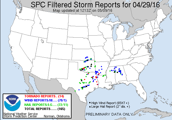
One of the most interesting things discussed today was a verification exercise. While SFE 2016 was not occurring on Friday, 29 April 2016, the testing phase of the CLUE provided ARW and NMMB members valid for Friday that we could compare and subjectively verify today. Friday was a particularly exciting day locally, as Norman, Oklahoma was placed under a tornado warning in the late afternoon/early evening hours. Luckily, Norman did not experience a tornado, but did experience severe hail and gusty winds from the storm. The SPC reports as of 2 May 2016 are:
For Friday, we compared an ARW member and an NMMB member using reflectivity fields (both 1km and composite reflectivity), UH, temperature, dew point, and CAPE. Some issues were noted with the depiction of the stratiform by the NMMB member, and displacement errors occurred with both cores. However, one large difference between the cores was found in the temperature, dew point, and subsequent CAPE fields. Comparing the temperature fields between the two members shows an almost ten degree difference in the NMMB across north Texas, with temperatures depicted in the 90's. While we don't have the verification panels for this event due to the experiment not yet being run, forecasters recall that the temperatures were actually in the 80's, closer to what the ARW depicts. In the following plots, the ARW member is on the left, and the NMMB member is on the right. All plots are shown for 2100 UTC, though the links will go to the entire forecast period compared.

The NMMB member was also quite dry compared to the ARW member.

As a result, the CAPE field was much more robust in the ARW member than in the NMMB member, and would be more supportive of strong convection off the dryline. The CAPE field of the ARW member also better matches the SPC mesoanalysis of CAPE. However, the pattern of the CAPE in the NMMB was fairly accurate, with a corridor of high CAPE through central Texas. Participants also noted that the ARW was quite aggressive with the northward extension of the CAPE.

 |
| SPC mesoanalysis of SBCAPE at 2100 UTC |
No comments:
Post a Comment